Best places for mangrove tours
KUKUP Island and Tanjung Piai in the south-west of Johor are carpeted with the country’s biggest colony of mangroves, which is home to many unique species of flora and fauna.
In view of their rich natural heritage, both have been declared as national parks and are known worldwide as the best destinations for mangrove tour.
The national parks are located next to each other.
Kukup Island is famed as the biggest mangrove island in the country, while Tanjung Piai is known as the southern-most tip of mainland Asia.
The i647ha island is surrounded by 800ha of mudflats.
Found aplenty in the mudflats are mud-skippers, mangrove crabs and many bird species which feed on tiny creatures found on the mudflats during low tide.
The island is just a stone’s throw away from the 150-year-old fishing village of Kukup, which sees droves of tourists coming from near and far during weekends and public holidays to enjoy seafood and put up for a night or two at the homestays.
A one-hour boat trip is more than sufficient to tour the island.
There is a 30m tall viewing tower for the convenience of tourists to get a 360-degree view of the vast green vista of mangrove trees covering the island.
Apart from the rustling leaves, the chirping of birds also join in the chorus of the mangrove forest to provide the only audio entertainment for anyone taking the boat ride and enjoying the breeze.
Remember to bring a pair of binoculars, as there are plenty of opportunities for bird-watching.
There is a suspension bridge across the forest for those who dare to walk across the shaky bridge.
You can cover the whole island by foot as the 800m of boardwalk will take you around the eastern part of the island, and the journey takes about two hours or less.
Walk slowly and quietly if you want to have a close encounter with the creatures of the mangrove and the different types of vegetation on the forest floor.
Remember, some long-tailed macaques and birds may be watching you without your knowledge.
There are boards which carry information about the mangrove forest along the way.
In Tanjung Piai, eight kilometres of mangrove forest front the Straits of Malacca, and about 400ha of intertidal mudflat.
It covers an area of 926ha, and 526ha consist of coastal mangroves.
It was declared a Ramsar site in 2003. The Ramsar Convention is an international treaty for the conservation and sustainable use of wetlands, which recognises the fundamental ecological functions of wetlands and their economic, cultural, scientific, and recreational value.
The entrance to the Tanjung Piai national park is a huge landmark.
The boardwalk leads visitors to a rotating globe, which marks the southern most tip of mainland Asia, as well as the best spot for photography.
Expect strong wind and waves here as it is the intersection of the Johor Straits and the Straits of Malacca.
During fine weather, it is possible to spot some of the Karimun Islands of Indonesia.
At the end of the tour, one will be sufficiently educated on the importance of mangrove trees as a natural barrier in reducing coastal erosion.
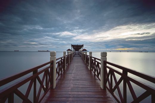
A long boardwalk at the Tanjung Piai National Park which leads to the middle of the sea.
~News courtesy of New traits Times~
KUKUP Island and Tanjung Piai in the south-west of Johor are carpeted with the country’s biggest colony of mangroves, which is home to many unique species of flora and fauna.
In view of their rich natural heritage, both have been declared as national parks and are known worldwide as the best destinations for mangrove tour.
The national parks are located next to each other.
Kukup Island is famed as the biggest mangrove island in the country, while Tanjung Piai is known as the southern-most tip of mainland Asia.
The i647ha island is surrounded by 800ha of mudflats.
Found aplenty in the mudflats are mud-skippers, mangrove crabs and many bird species which feed on tiny creatures found on the mudflats during low tide.
The island is just a stone’s throw away from the 150-year-old fishing village of Kukup, which sees droves of tourists coming from near and far during weekends and public holidays to enjoy seafood and put up for a night or two at the homestays.
A one-hour boat trip is more than sufficient to tour the island.
There is a 30m tall viewing tower for the convenience of tourists to get a 360-degree view of the vast green vista of mangrove trees covering the island.
Apart from the rustling leaves, the chirping of birds also join in the chorus of the mangrove forest to provide the only audio entertainment for anyone taking the boat ride and enjoying the breeze.
Remember to bring a pair of binoculars, as there are plenty of opportunities for bird-watching.
There is a suspension bridge across the forest for those who dare to walk across the shaky bridge.
You can cover the whole island by foot as the 800m of boardwalk will take you around the eastern part of the island, and the journey takes about two hours or less.
Walk slowly and quietly if you want to have a close encounter with the creatures of the mangrove and the different types of vegetation on the forest floor.
Remember, some long-tailed macaques and birds may be watching you without your knowledge.
There are boards which carry information about the mangrove forest along the way.
In Tanjung Piai, eight kilometres of mangrove forest front the Straits of Malacca, and about 400ha of intertidal mudflat.
It covers an area of 926ha, and 526ha consist of coastal mangroves.
It was declared a Ramsar site in 2003. The Ramsar Convention is an international treaty for the conservation and sustainable use of wetlands, which recognises the fundamental ecological functions of wetlands and their economic, cultural, scientific, and recreational value.
The entrance to the Tanjung Piai national park is a huge landmark.
The boardwalk leads visitors to a rotating globe, which marks the southern most tip of mainland Asia, as well as the best spot for photography.
Expect strong wind and waves here as it is the intersection of the Johor Straits and the Straits of Malacca.
During fine weather, it is possible to spot some of the Karimun Islands of Indonesia.
At the end of the tour, one will be sufficiently educated on the importance of mangrove trees as a natural barrier in reducing coastal erosion.
A long boardwalk at the Tanjung Piai National Park which leads to the middle of the sea.
~News courtesy of New traits Times~
No comments:
Post a Comment